I’m a few days late posting about Flag Day, but I will post this photo from last year. The image was taken in old downtown Wickenburg where the local American Legion Post placed these flags. The Post places roughly 300 flags on the main drags all around town. Click on the image to enlarge.
I hiked up to the marker that defines the northeast corner of our property. I took a series of images from the corner panning from south to west. This is the view from the top of our lot.
Our lot is about a half acre. The pad where the house sits is about a third of the total property. We like the isolation from the houses to the north and west. This allows the wildlife to run as they will up here. It’s sort of like an entertainment center that we don’t have to subscribe to! Click on the panoramic thumbnail above to view the full-sized panoramic image.
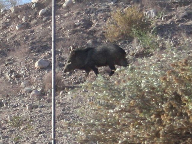
I guess that the javelina knew that we posted a crossing sign; late this afternoon at around six PM, Beethoven started barking. It turned out that he saw a herd of javelina crossing through our back yard. I ran to get my camera and caught this image of the last of them up on the hill. There were two females, four juveniles and this must be the daddy “cactus rat.”
Yesterday, Verna prepared this sumptuous Italian-style lunch. She made a tasty antipasto salad and penne rigate pasta with turkey marinara sauce and garlic toast. Sje poured a shot of limoncello on the side as a digestivo. Good stuff! Click on the image to enlarge.
I planted three sign posts this week – two to accommodate no trespassing signs near both entrances to the RV drive, and one in the wash behind the house. I bought the no trespassing signs when we bought the other materials, so they were installed on Tuesday.
Today, the “JAVELINA XING” sign arrived in the mail. I installed it on the post in the wash. Verna took this photo.
The sign is installed approximately where we have seen javelina in the past. Verna took the image below to show the location of the sign next to the RV drive. Click on either image to enlarge.
These three aerial views came from the Maricopa County Assessor’s website. I can’t be sure of the dates the images were taken but I can guess based on the progress. Click on the image to advance to the next image.
The first image was taken between 2008 and the first half of 2010; it was labeled 2010 on the county website and shows the parcel and the bare pad. The second image was taken in about November of 2010 judging from the building progress; this image was labeled 2011. The third and last image had to have been taken in late 2011, judging from the shrubbery and landscape; it is marked 2012 on the county site.
Unfortunately, the county only maintains images for three years; it would have been nice to have a view of the parcel prior to the pad excavation.