15 Search results

For the term "+Vulture+Peak".

Panorama of Hassayampa River and Wickenburg

We took a scenic drive up to the northeast from town today. When we got to the summit of Scenic Loop Drive, Verna took an image back toward town. I cropped the image into a panoramic view of the Hassayampa River with Wickenburg in the distance and Vulture Peak and the Vulture Mountains beyond. Click on the thumbnail below to see the full-sized panoramic image.

town-pan.jpg

Valley View Panorama

valley-pan.jpg

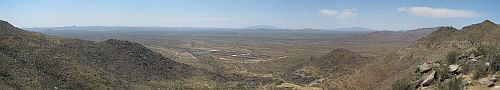
We took a little ride today up to Yarnell, a little mountain mining town on State Route 89 north of Wickenburg. There is a steep, winding section of the road between Congress and Yarnell. On the downhill side, there is a scenic pull-out with this view of the valley south of the Weaver Mountains.

I composed this panoramic view of the valley from three exposures which I later stitched into this panoramic image. On the horizon, you can see Vulture Peak towards the left of the image; moving right, you can see the Harcuhala and Harcuvar mountain ranges toward the right of the image. In the valley below, you can see a large stockyard in the left center and the town of Congress toward the right. Click on the panorama for the full-size view.

Hassayampa River Valley Panorama

hassayampa-valley-pan.jpg

We took a nice scenic drive today up the Hassayampa River Valley. When we got to the top of one of the ridges we crossed, Verna took an image back toward the Vulture Mountains in the distance with the Hassayampa in the foreground and the Town of Wickenburg in the middle ground. Click on the thumbnail to see the full panorama. Scroll to the right to see Vulture Peak in the distance.