This is a late-afternoon image of a cumulus cloud just to the west of the house. The sun’s rays give it a spectacular halo! Click on the image to enlarge.

This is a late-afternoon image of a cumulus cloud just to the west of the house. The sun’s rays give it a spectacular halo! Click on the image to enlarge.

It was not raining here, but there must have been a few water droplets to form this faint rainbow seen just east of us this evening as we were walking the dogs. Click on the image to enlarge.
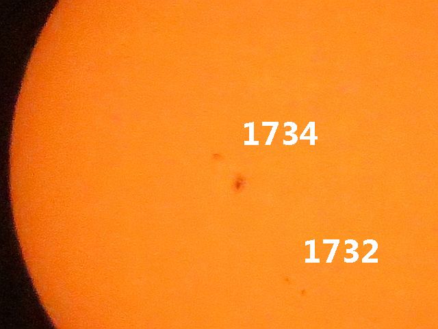
I took this image of the Sun today with several sunspots visible. Over the next few days, M-Class solar flares are possible.

Today and tomorrow are supposed to be at or near record setting for these dates. I took the image above of the clock/temperature readout on our patio at about 3:30 this afternoon.
The following discussion is from the National Weather Service:
NEAR RECORD HIGH TEMPERATURES WILL CONTINUE FRIDAY. A MODEST COOLING TREND WILL BEGIN DURING THE WEEKEND...THOUGH TEMPERATURES WILL REMAIN ABOVE AVERAGE THROUGH AT LEAST THE MIDDLE OF NEXT WEEK. SKIES WILL REMAIN MOSTLY CLEAR...WITH PERIODS OF PASSING HIGH CLOUDS.DISCUSSION...
REST OF THIS AFTERNOON THROUGH SUNDAY...TEMPS HAVE REACHED WELL INTO THE 90S THIS AFTERNOON AT MOST LOW ELEVATION LOCATIONS. PHOENIX BROKE THE PREVIOUS RECORD OF 91...REACHED 93 SO FAR AS OF THIS WRITING. YUMA WILL AT LEAST TIE THEIR RECORD FOR THE DATE...95. ANTICIPATE VERY SIMILAR HIGH TEMPERATURES FRIDAY. HOWEVER...THE UPPER RIDGE WILL BE WEAKENING. ON SATURDAY...THE RIDGE WILL HAVE BEEN FLATTENED AND SHORT WAVE PASSES BY BRINGING HIGH CLOUDS. THUS MAX TEMPS DROP A LITTLE BIT. ON SUNDAY A STRONGER SHORT WAVE PASSES BY...ALTHOUGH CENTERED FURTHER NORTH...FOR SOME SLIGHT ADDITIONAL COOLING. BUT OVERALL...WEEKEND TEMPS WILL STILL BE WELL ABOVE NORMAL.

I have several bulbs planted in a shallow box in the courtyard. This morning, I discovered that there were buds opening on my paperwhites. It rained overnight and we had a little freezing rain pellets on top of the soil in the box. That’s why you don’t see the brown potting soil in the background – it’s ice. Click on the image to enlarge.

Some white puffy clouds floated across the sky this afternoon. I captured this image of the sun’s rays as one of the clouds passed in front of it. Click on the image to enlarge.