Nerdliness

Winter Solstice

Today is Solstice, the shortest day in the Northern Hemisphere – according to the solar ephemeris for our location, the length of our day will be approximately nine hours and fifty-four minutes.

Solar Ephemerides for
Sunday, December 21, 2008
Torrance, California:

Twilight Begins:

05:55

Sunrise:

06:54

Transit:

11:51

Sunset:

16:48

Twilight Ends:

17:47

Total Daylight (H:M):

09:54
The table at the left shows the various events associated with the motion of the Earth at our longitude and latitude. Twilight is the time when first light from the sun begins to illuminate the atmospheric particles or when last light ceases illumination. Sunrise and sunset are the times when the limb (edge) of the sun peeks above or disappears below the horizon. Transit is when the sun midpoint crosses the meridian, or longitude of our location.

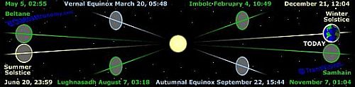
The graphic below is taken from a very interesting website, Archaeoastronomy.com. On their website, you can learn about Equinoxes, Solstices and Cross Quarters which are moments shared planet-wide, defined by the earth’s tilt and the sun’s position on The Ecliptic along 45° arcs.

This neat graphic is put into motion on Archaeoastronomy.com.
Solstice

The Mount Wilson Tower Cam

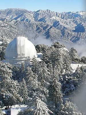
Mount Wilson Weather CameraOne way to keep track of the weather is to find webcams near the area in which you’re interested. Today, after the storm passed through, I took a look at the webcam on the Mount Wilson Solar Observation Tower. I saw this snowy fairyland and the observatory dome housing the famous Hooker 100 inch Newtonian Telescope at the left.
Here’s some history on the Hooker Telescope from the Mount Wilson Observatory:

The Hooker 100-inch telescope is named after John D. Hooker, who provided the funds for the giant mirror. It was the largest telescope in the world from 1917 to 1948 when the 200-inch telescope was built on Palomar Mountain 90 miles to the southeast. Many great discoveries were made with the 100-inch telescope Edwin Hubble’s refinement of the distance scale of the universe. The first optical interferometer ever used for astronomical research was used on the 100-inch telescope to measure the sizes of distant stars for the first time in 1919.

The 100-inch telescope has three optical configurations available to meet the requirements of a wide variety research projects. A very high-resolution spectrograph is located at the telescope’s Coudé focus. Located on the ground floor of the 100-inch telescope dome, the Aluminizing Room is used to recoat all of the telescope mirrors at the observatory.

Fog at Two Harbors

I like to internet surf to the webcams at Catalina Island from time to time. This gives me a current perspective on the weather patterns and island activity. Today, I looked at the webcam at Two Harbors and saw this foggy apparition of Ship Rock looming in the distance.

Some days, though, it is clear enough to see the mainland and even the mountains inland. Roll the cursor over this image to see a clear day from Two Harbors.

The Ghost of Cassini

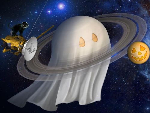
On this Halloween, the spooks and spirits are reaching far into space. This whimsical presentation of the Cassini Saturn mission, with ghost, pumpkin and black cat demonstrates a lighter side of NASA for the Halloween holiday.

ghost-of-cassini.jpg

Solar Ephemeris

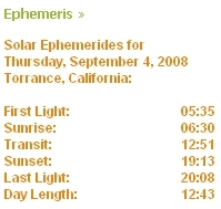
ephemeris.jpgQuietly, in the bottom of the sidebar to the left, is a widget that displays the times of today’s solar events. An ephemeris is a tool used by navigators and astronomers to predict celestial events, like eclipses, moon rise, occultations (planets or stars crossing paths) and the like.

My widget (home grown – written in PHP scripting language) accurately predicts solar events at the longitude and latitude for Torrance, CA, but will be approximately correct anywhere within a fifty mile radius.

I’m working on a version of this where you can put in your zip code or longitude and latitude to get your local solar ephemerides. Still in work, but possibly will materialize soon.

Disappearing High Tension Lines

Not far from where I work, there is a golf course and a tennis club. In the bad old days, these both were just a cleared out area where the power lines and their unsightly towers ran through on their way from the electric power plants in El Segundo and Playa del Rey on the way to distribution points east.

Planners decided at some point that the wires were not a desirable feature and found a way to run these high wires underground. I took this panorama from the east end of the subterranean power line run to the west end where the towers resume. You can see the lines disappearing as they plunge into the ground at the near end. The golf course is directly behind the tree line along the street running from left to right. I circled the west tower where the lines come back up about a half mile in the distance on the far right end.

power line

I sometimes walk down to this end of the run from the building where I work, which is at the far end of the run in this picture. About a mile round trip and a good after lunch walk.