Panoramas

Northeast Corner Panoramic Image

I hiked up to the marker that defines the northeast corner of our property. I took a series of images from the corner panning from south to west. This is the view from the top of our lot.

ne-corner-pan.jpg

Our lot is about a half acre. The pad where the house sits is about a third of the total property. We like the isolation from the houses to the north and west. This allows the wildlife to run as they will up here. It’s sort of like an entertainment center that we don’t have to subscribe to! Click on the panoramic thumbnail above to view the full-sized panoramic image.

Vulture Mountain Panorama

vulture-pan.jpg

This is a view of the Vulture Mountain Range located south of Wickenburg. Verna took this photo from US 60 southeast of the range and I cropped it into this panoramic view. Vulture peak, the highest point in the range, is the prominent feature in the distance near the center of the panorama.

Scenic Panoramic View from US60/BNSF Railroad

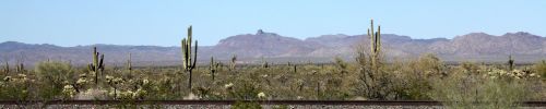
It’s a real shame that only freight moves along this section of BNSF’s rail between Surprise and Morristown, AZ. A dome car on a passenger train traveling along this route would be treated to this scenic panorama of desert vegetation (Teddy Bear Cholla, Saguaro Cacti, Palo Verde and others) with jagged Arizona mountains in the distance.

bnsf-us60-pan.jpg

If the hypothetical passengers were to continue along the BNSF route to Las Vegas, they would also be treated to scenes along the Hassayampa River and then on into the Joshua tree forests of northwest Arizona. If you don’t like the scenery (who wouldn’t?), just wait five or ten minutes and one kind of beautiful scenery will be replaced by another.

I can’t take credit for the panoramic image since I cropped it from one of Verna’s photos from yesterday. Click the thumbnail above to see the full-sized panorama.

Casandro Dam

casandro-pan.jpg

We took the truck in for service today. On our walk back home (about ¾ of a mile), we paused behind a business to take this panoramic image of the Casandro Dam and our house. Wait! You can’t see the house since it’s in the canyon just below the big white house on the second ridge near the center of the panorama. Click on the image to see full-size panoramic image.

A Desert Graveyard

Desert Graveyards, because of the arid climate, seldom resemble the lawn-covered ones elsewhere. This is the graveyard in Congress, Arizona where there are many very old graves. It was interesting visiting this place today as we ventured off the pavement. Next time, there is a ghost town near this place we want to visit. Click on the thumbnail image to view the full-sized panorama.

graveyard-pan.jpg

Panorama of Hassayampa River and Wickenburg

We took a scenic drive up to the northeast from town today. When we got to the summit of Scenic Loop Drive, Verna took an image back toward town. I cropped the image into a panoramic view of the Hassayampa River with Wickenburg in the distance and Vulture Peak and the Vulture Mountains beyond. Click on the thumbnail below to see the full-sized panoramic image.

town-pan.jpg