Arizona

Snow Plow

snow-plow.jpgTwo years ago, we rented a motor home and took a trip over the Christmas Holidays. Our ultimate goal was to see Grand Canyon in the winter and, hopefully, with snow.

We stayed the first night in Twentynine Palms near Joshua Tree National Park. In the morning, we drove through the park toward Intestate 10 and then to Wickenburg, AZ.

When we stayed at the Horsepitality RV park in Wickenburg on Christmas Eve, we had no idea that we would have a house there in two years. We will likely be there over the Christmas weekend this year too.

On Christmas Day, we drove over to Interstate 17 to head to a campground in Flagstaff. By the time we got to the campground, there was about a foot and a half of snow on the ground.

We drove up to the Canyon the next morning. We stayed in the campground in the park and there was plenty of snow there too. As a matter of fact, we got stuck in snow for a couple of hours while we waited for Triple A to pull us out. Quite an adventure.

Other than the little mishap, the highways and roads were all quite well plowed. I took this image as we passed a southbound snowplow on US 180 as we were going northbound toward Grand Canyon. Click on the image to enlarge.
GPS Hints and Tricks

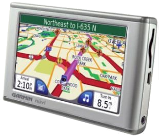
gps.pngOne of the limitations of my Garmin Nüvi 205W GPS is its inability to select a custom route. Unlike Google Maps™ and other popular on-line map resources, the Garmin only allows one waypoint to be programmed in addition to the destination.

When we leave the LA area to go to the new house (something we have been and will be doing a lot), I like to take a different route than the GPS decides. The GPS always wants to send me to Banning via state route 60 through Riverside which is an inferior route to joining up with I-10 via I-15. There is less traffic and construction that way, plus 60 takes us over the winding road east of Moreno Valley.

I searched for some information on setting a custom route on my GPS and found a blog that had tons of information: Tricks, Tips, Work Arounds, Hints, Secrets and Ideas for Garmin GPS. I spent quite a lot of time looking through the many articles there and found out a whole lot I didn’t already know about my GPS.

I eventually stumbled on a tip that solved 70 percent of my problem. I programmed a precision waypoint on the ramp from northbound I-15 to eastbound I-10. I say 70 percent because it still wants to take me up to I-105 and east. Fortunately, It will recalculate the route as I drive where I want to go and once we’re east of I-605 it shows the preferred route. Even though the hints and tips website didn’t solve my exact problem 100 percent, it showed me how to get more out of the GPS.

A Picnic at MacGuire Park

macguire-park.jpg

I took this picture last month in MacGuire Park, a nice little place with BBQ stands and a shaded playground. Near the middle of the park there are several picnic tables. Bob and the dogs were enjoying the shade as we waited while the chicken breast cooked over the charcoal fire.

Animated Slideshow Transitions

I recently upgraded to the latest version of the Flash™ authoring tool that I use. There are lots of new features in the latest release, several of which I used for the slideshow seen here.

The tool lets me break up the images into whimsical shapes and then the effects browser allows me to preview the transition effect before choosing it. This is the result:

The images were made in November at the site of the new house in Arizona.

Quacking and Snacking

gambels-quail.jpg

While we were in Wickenburg, we bought a bag of wild critter feed and tossed it into the little wash in our back yard. Sure enough, about a dozen Gambel’s Quail came to feed. This handsome guy was one of several we saw in the wash quacking away as they snacked on the critter food. Click on the image to see an expanded view.

Arizona Winter Weather Preview

az-christmas.jpgI took this photo from Interstate 17 just north of the Phoenix Metro area near Lake Pleasant. It was Christmas Day 2008 and we were on our way to the Grand Canyon via Flagstaff.

Image: Saguaro Cactus along I-17 – click to enlarge.

We stayed in Wickenburg on Christmas Eve and drove down US 60 to get gas in Surprise. We drove on the north loop 101 over to I-17 and headed north from there. The further north we went, the more snow we saw on the ground. By the time we got to Flagstaff, everything was covered in snow.

Wickenburg is five thousand feet lower than Flagstaff, so while there may be a snow dusting or two in the winter, it will be nothing like the snow we saw at Flagstaff and the Grand Canyon.